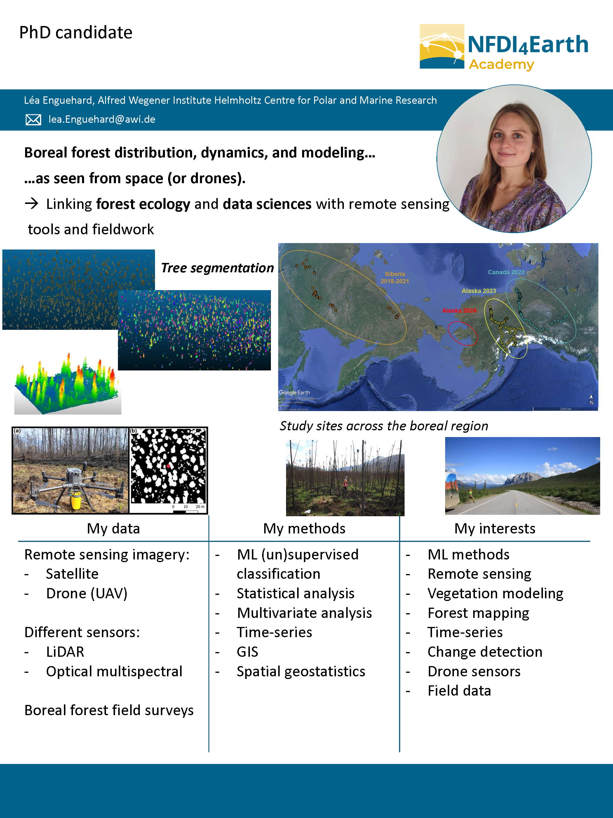
The first cohort
Multi-hazard events in tropical regions
In topical and mountainous regions, intense and convective rainstorms often trigger a set of coupled or cascading hazards in the basin scale that includes clusters of landslides, hillslope debris flows, flash floods, and channelized debris flows. The final stage of such events is marked on fans or low-land areas that are often populated, causing extensive disasters. These events have become more recurrent and intense over time, due to the increase of extreme rainstorms, and the urbanization of susceptible areas.
The hazard assessment for such phenomena faces big challenges. One of them is the general lack of consensus and recognition of the multi-hazard phenomena as a whole, which translates in a lack of analysis of world-scale patterns of such events. Another big challenge in the hazard assessment are associated to their modelling. Several approaches have been developed to model their sub-processes independently (hydrology, flooding, slope stability, and debris flow runout). Even though individual models can reach high modelling accuracy, the interaction with other processes is neglected and does not give precise results as a multi-hazard assessment. On the other hand, some integrated multi-hazard modelling approaches have emerged, which account for the interactions within processes. Nonetheless, these models are heavily reliant on data and computational resources and propagate several uncertainties, making it difficult to trace the influence of single variables in the final results. The use of Artificial Intelligence (AI) algorithms is a growing field, and many applications have been developed to increase the accuracy of susceptibility, hazard and risk assessment using AI, taking advantage of big data availability. Nonetheless, the interpretability of very complex AI algorithms is sometimes very challenging from a physical perspective, undermining its applicability in different environments and credibility.
My research will focus in addressing these challenges. To start, I want to collect information about multi-hazard events in tropical areas from disaster databases and carry out a multi-variate analysis with all the information I can gather about them. Using remote sensing data, I want to understand the patterns and differences within multi-hazard interactions in different environments and terrains. Once I have a clearer idea about their nature, I want to work with detection models that allow to map and locate multi-hazard events in the world using remote sensing data and IA algorithms. Finally, I will combine physical and AI models, using AI to improve the quality or quantity of input data for physical models, and using physical models to improve the interpretability of AI models that are used to models multi-hazard phenomena.
-----
Important publications
Arango, M. I., Aristizábal, E., & Gómez, F. (2020). Morphometrical analysis of torrential flows- prone catchments in tropical and mountainous terrain of the Colombian Andes by machine learning techniques. Natural Hazards 130.
Aristizábal, E., Arango, M. I., & López, I. K. G. (2020). Definition and Classification of Torrential floods and Their Impact in the Colombian Andes. Cuadernos de Geografía: Revista Colombiana de Geografía, 29(1), 242-258.
Aristizábal, E., Arango, M.I., Gómez, F. J., Castro, S. M. L., Severiche, A. D. V., & Quintanilla, A. F. R. (2020). Hazard Analysis of Hydrometeorological Concatenated Processes in the Colombian Andes. Advances in Natural Hazards and Hydrological Risks: Meeting the Challenge 7-10.
Contact
arangocarmona[at]uni-potsdam.de
ESS methods
Remote
sensing, flooding and slope stability physical models
DS methods
Deep
Learning, Machine Learning, Bayesian Statistics
Software & tools
GIS, Python, R, Google Earth Engine
Libraries
GDAL/OGR,
Geopandas, Geemap, Scikit
Project title
tba
-----
Important publications
tba
Contact
tba
ESS methods
NA
DS methods
tba
Software & tools
tba
Libraries
tba

Stereo Observations of Clouds for LES Validation and Sub-scale Cloud Parameterizations (SOCLES)
Clouds
play a crucial role in the Earth's energy and water cycles, and their accurate
representation in numerical models is crucial for accurate weather prediction
and climate projection. However, shallow cumulus clouds are highly
heterogeneous and quickly evolving, making it difficult to represent their
impact on the larger-scale flow and energy budget.
Our
project aims to address this challenge by combining high-frequency observations
from multiple stereo cameras with Large-Eddy Simulation (LES) at a mid-latitude
meteorological supersite. The detailed data provided by the stereo cameras will
be used to validate LES simulations and improve cumulus parameterizations in
weather and climate models. By utilizing open boundaries, multiple nesting, and
detailed topography in the LES, we hope to achieve a higher level of realism in
simulated clouds.
We
are also proposing an algorithm that uses ray-tracing techniques to create
camera images from simulated clouds. These images will allow for the comparison
of high-resolution meteorological models with camera measurements, providing a
new way to evaluate the accuracy of the models.
In
summary, our project aims to improve our understanding of the fine-scale
structures of shallow cumulus clouds and their impact on the larger-scale flow
and energy budget. By capturing clouds in greater detail and utilizing advanced
simulation techniques, we hope to improve the representation of these important
features in numerical models, ultimately leading to more accurate weather
prediction and climate projections.
ESS methods
ICOsahedral Nonhydrostatic Large Eddy Model (ICON-LEM), Dutch Atmospheric Large-Eddy Simulation Model (DALES), Photogrammetry, Remote Sensing
DS methods
Cluster
Analysis (DBSCAN, KMeans, Mapper), Support Vector Machines, Gradient Tree
Boosting, Principal Component Analysis (PCA), Neural Networks, Machine Learning
Neural
networks, ML, etc.
Software & tools
Python, C++, Fortran, Blender, Shell Script, Github, Jupyter, Anaconda, Pip, Linux, Windows, Microsoft Office
Libraries
Numpy,
Matplotlib, scikit-learn, SciPy, TensorFlow, Keras, PyTorch, scikit-tda,
Pandas, OpenCV, Numba, netCDF4, moviepy
Project title
tba
-----
Important publications
tba
Contact
tba
ESS methods
tba
DS methods
tba
Software & tools
tba
Libraries
tba
Project title
tba
-----
Important publications
tba
Contact
tba
ESS methods
tba
DS methods
tba
Software & tools
tba
Libraries
tba
Identification
and investigation of mass movements on tsunamigenic coastal landforms
Landslide
induced tsunamis have come into focus of scientific literature since 2018, when
two catastrophic aseismic tsunamis hit the Indonesian coastline in Palu and the
Sunda Strait, resulting in thousands of deaths. Waves induced by landslides are
very local events but they can reach extreme heights compared to seismically
induced tsunamis. Early warning is usually not possible for those events
because the time that passes between wave generation and their arrival at the adjacent
coastlines is often only minutes. The objective of this project is to investigate
the characteristics of landslide tsunamis, to identify areas that might be
endangered by future events and to model landslide tsunami scenarios in those
areas. The focus of the study is the Indonesian coastline as it has been
especially affected in the past.
In a
first step, a literature review on historical landslide tsunami events was conducted.
Parameters describing the landslide, the generated tsunami wave and landslide
triggering events were extracted from scientific literature and tsunami
databases. Further parameters describing the waterbody geometry and sea floor
morphology were extracted with geoinformation systems from spatial data. All
case studies and their related parameters were collected in a database. This database
contains information on more than one hundred case studies and can help finding
similarities between the case studies and identifying areas that are especially
prone to that hazard.
The
next step focuses on coastal landslide susceptibility analysis. Parameters that
have been widely employed for landslide susceptibility investigations, combined
with the knowledge gained from the database generated in the first step, will
be used for the analysis. For highly endangered areas, the stability of slopes
will be modelled numerically with particle flow codes. With the help of those
models, parameters can be estimated, which are critical for the generation of
tsunami waves, such as landslide volume, landslide velocity or sliding material.
Contact
k.dohmen[at]tu-berlin.de | Department Website | ResearchGate
ESS methods
Remote
Sensing, Susceptibility Analysis, Slope Stability
DS methods
Artificial
Neural Networks, Decision Trees, Bivariate Analysis, Interactive Data
Visualization
Software & tools
R, QGIS, ArcGIS, SPSS Modeler
Libraries
Shiny, leaflet, sf
Project title
tba
-----
Important publications
tba
Contact
tba
ESS methods
tba
DS methods
tba
Software & tools
tba
Libraries
tba
Towards
Ecosystem Reanalysis by Coupling Water and Carbon Cycles
This
Ph.D. topic is a part of the Collaborative Research Centre (CRC), cluster C,
project C03 and undertaken at the research group ‘Stochastic Analysis of
Terrestrial Systems’ at the Institute of Bio- and Geosciences (Agrosphere),
Research Centre Jülich.
The
primary aim of this Ph.D. research is to investigate the impact of uncertain ecosystem parameters
on the coupled water, energy, and biochemical cycles across Europe. The
emphasis is on the
variability of water and carbon fluxes in space and
time, which is significant for simulating the impact of land use and land-cover
change on these cycles. We hypothesize that continental-scale net ecosystem
exchange (NEE) from a reanalysis with improved ecosystem parameters and
improved representation of soil respiration (SR) will better correlate to
observed total water storage (TWS) variability.
To attain our research goals, we will implement the
iterative ensemble smoother (IEnS) coupled with Community Land Model, version 5
(CLM5) (Lawrence et al., 2019) to estimate ecosystem parameters (i.e., soil and
vegetation) at well-equipped measurements sites from the Long-Term Ecological
Research (LTER) and FLUXNET networks by assimilating long-term time series of
soil moisture, leaf area indices, and NEE. Using this approach, we will
establish a prototype for ecosystem reanalysis for a period of 30 years
(1991-2020) over Europe by combining the acquired knowledge of ecosystem
parameters and soil respiration.
Contact
f.eloundou[at]fz-juelich.de
ESS methods
Iterative
Ensemble Smoother (IEnS)
,
Ensemble
simulations
Probabilistic
statistics,
Time
series analysis,
Model
validation from Eddy covariance and Meteorological measurements
DS methods
tba
Software & tools
Python, Fortran, Linux, Gitlab, CLM5, Probabilistic data association filter (PDAF), JSC Supercomputer resources
Libraries
tba
Quality
assessment of analytical data in resource and environmental research (QuARUm)
Increasing
amounts of analytical data are produced and published in geochemistry, like in
all other scientific fields. The number of geochemical databases and the amount
of entries are growing. However, quality assessment of literature data is often
complicated or simply impossible due to missing background information
(certified reference materials, blanks, interference correction, machine drift,
daily performance, etc.). Therefore, we aim to develop a tool that helps
researchers to evaluate the quality of their geochemical analytical data.
The
research project is a collaboration between the geochemistry research group at
the Constructor University Bremen and the software engineering research group
from TU Dortmund. We will develop a low-code environment that enables
geochemists to objectively assess the quality of geochemical data based on
fully modifiable sample-specific criteria. The quality assessment will be
applicable directly to self-produced analytical data, literature data in
publications and large-scale geochemical databases. Furthermore, the software
tool will allow processing of geochemical raw data to obtain, for example,
absolute concentration data from an ICP-MS measurement. The raw data processing
will also be modifiable, based on the respective applications and user needs,
and fully visible, unlike existing commercial software solutions that operate
mainly as black boxes.
I am
a geochemist researching the behaviour of critical metals in Precambrian and
modern natural systems. During the QuARUm project, I will compile and develop
geochemical and statistical criteria for the data quality assessment. We will implement
sufficient criteria for a broad spectrum of different sample types that can be
used easily by the geoscience community. Here I can use the experience I have gathered
in the last years in analysing (ultra)trace elements in various sample types. Furthermore, I will work on an automated data
processing protocol to compute final concentration data from ICP-MS and ICP-OES
raw data. In addition, I will act as an interface between Data Science and my
geochemist colleagues so that we can develop a software tool that is easy and
intuitive to use for the broad geochemistry/geoscience community.
-----
Important publications
Ernst, D.M., Bau, M. (2021)
Banded iron formation from Antarctica: The 2.5 Ga old Mt. Ruker BIF and the antiquity of lanthanide tetrad effect and super-chondritic Y/Ho ratio in seawater. Gondwana Research 91, 97–111.
Ernst, D.M., Schier, K., Garbe-Schönberg, D., Bau, M. (2022) Fractionation of germanium and silicon during scavenging from seawater by marine Fe (oxy)hydroxides: Evidence from hydrogenetic ferromanganese crusts and nodules. Chemical Geology 595.
Schier, K., Ernst, D.M., de Sousa, I.M.C., Garbe-Schönberg, D., Kuhn, T., Hein, J.R., Bau, M. (2021) Gallium-aluminum systematics of marine hydrogenetic ferromanganese crusts: Inter-oceanic differences and fractionation during scavenging. Geochimica et Cosmochimica Acta 310, 187–204.
Contact
dernst[at]constructor.university
ESS methods
ICP-MS (also SF-ICP-MS and QQQ-ICP-MS); laser-ablation ICP-MS; ICP-OES
DS methods
data
visualisation, linear regression
Software & tools
Python
Libraries
pyrolite,
SciPy
Detection
and attribution of anthropogenic drivers in extreme events
“Humans
– through decades of land-use change and intensified water use and management –
have caused persistent modifications in the coupled water and energy cycles of
land and atmosphere.” This is the central hypothesis of the Collaborative
Research Center 1502. To investigate this claim, an integrated modeling system
coupling earth, atmosphere and the sub-surface is created and analyzed by the
various subprojects of the CRC.
Our
subproject is concerned with analyzing meteorological extreme events like heat
waves and droughts. We investigate potential changes in the characteristics of
such extremes and the drivers of such changes.
Contact
tfohrmann[at]uni-bonn.de |
Colloaborative Research Centre DETECT
| Working Group on Climate Dynamics | github.com/tfohrmann
ESS methods
Numerical
Weather Prediction and Reanalysis Models, Meteorological Remote Sensing
DS methods
Bayesian
Statistics, Extreme Value Statistics, Bayesian Hierarchical Modeling, Machine Learning, Information Compression,
Statistical Inference
Software & tools
Python,
C, High Performance Computing
Libraries
SciPy,
Pandas, Sklearn, Keras, Tensorflow, Xarray, Statsmodels

Precipitation
processes
Atmospheric
models still do not adequately represent precipitation generating processes,
which is partly responsible for their deficiency in reproducing observed
regional trends in total water storage (TWS). We will quantify these
deficiencies in the Integrated Monitoring System (IMS) by exploiting especially
polarimetric radar observations with inherent information on precipitation
generating processes aloft. The use of polarimetric microphysical retrievals
and the evaluation of climate model runs in radar observation space will enable
us to compare the observed and simulated impact of greenhouse gas forcing and
regional anthropogenic interventions on precipitation generation. The project
focuses on Europe, with radar data from Germany and Turkey. This project is
part of the Collaborative Research Centre 1502 – DETECT.
Contact
jgiles[at]uni-bonn.de | ResearchGate | DETECT Cluster A04 | github.com/JulianGiles
ESS methods
Numerical
modelling analysis, weather radar data processing, remote sensing
DS methods
Statistical
analysis, trend analysis, georeferenced visualization
Software & tools
Python,
Git, Linux/UNIX
Libraries
xarray,
wradlib, cartopy, scipy, numpy, matplotlib
Project title
tba
-----
Important publications
tba
Contact
tba
ESS methods
tba
DS methods
tba
Software & tools
tba
Libraries
tba
Project title
tba
-----
Important publications
tba
Contact
tba
ESS methods
tba
DS methods
tba
Software & tools
tba
Libraries
tba
Project title
tba
-----
Important publications
tba
Contact
tba
ESS methods
tba
DS methods
tba
Software & tools
tba
Libraries
tba
The biogeochemistry of dissolved organic
matter in hydrothermal Guaymas Basin sediments
I am a doctoral candidate working on the
biogeochemistry of dissolved organic matter (DOM) in hydrothermal Guaymas Basin
sediments. The Guaymas Basin is a young, active spreading ridge in the Gulf of
California. During my Ph.D., I will characterize the DOM composition in the
sediment and porewater using ultrahigh-resolution mass spectrometry and link
the DOM composition with deep biosphere-related microbial metabolism along
temperature and redox gradients. I want to identify whether carbon-rich but
low-temperature hydrothermal systems have the potential to function as an
organic carbon storage cell or whether these ecosystems are a source of organic
carbon to the deep ocean.
Contact
Melina.knoke[at]uol.de
|
@Melina_Knk| https://uol.de/en/icbm/marine-geochemistry/staff/melina-knoke
ESS methods
ultra-high resolution mass spectrometry
(FT-ICR-MS), (compound-specific) isotope analysis, 16S rRNA
DS methods
tba
Software & tools
tba
Libraries
tba

Data
Assimilation and Machine Learning in the Upper Atmosphere
This
research is concerned with data assimilation and machine learning in the upper
atmosphere - the ionosphere and thermosphere (IT) system. The specification and
prediction of the IT system is critical for space-based services and
technologies such as communications, navigation, agriculture, security, banking
and healthcare. Although there are well-established data assimilation
techniques in tropospheric numerical weather prediction, it is difficult to
apply these techniques to IT data assimilation due, among others, to the
physical, chemical and dynamical differences between the two systems. In other
words, in tropospheric weather forecasting, data assimilation solves the
initial value problem by giving the model the best estimate of the current
state of the atmosphere, which is then used to make forecasts. Unlike the
troposphere, the IT is strongly influenced by solar activity, geomagnetic
activity and forcing from the lower atmosphere. Since IT numerical models
typically do not resolve the external forcing in a self-consistent manner, data
assimilation in the IT requires additional consideration of model boundary
conditions. Combined data assimilation and machine learning techniques could
help to accurately specify both initial and boundary conditions. The
application of data assimilation and machine learning in IT is relatively new,
and the techniques remain experimental for operational space weather
applications. As a result, the inherent predictability of the IT system remains
largely unknown. The extent to which IT can be accurately predicted is
therefore an open scientific question.
Through
this research, we aim to contribute to existing open source initiatives with
new or improved tools and methodologies, explore machine learning-based
techniques for predicting solar and geomagnetic forcing inputs to the IT models,
perform data assimilation experiments with different kinds of observations, and
assess the predictability of the IT system.
-----
Important publications
Kodikara, T., Zhang, K., Pedatella, N. M., & Borries, C. (2021). The impact of solar activity on forecasting the upper atmosphere via assimilation of electron density data. Space Weather, 19, e2020SW002660. https://doi.org/10.1029/2020SW002660
Forootan, E., Kosary, M., Farzaneh, S., Kodikara, T., et al. (2022). Forecasting global and multi-level thermospheric neutral density and ionospheric electron content by tuning models against satellite-based accelerometer measurements. Scientific Reports 12, 2095. https://doi.org/10.1038/s41598-022-05952-y
Fernandez-Gomez, I., Kodikara, T., Borries, C., et al. (2022). Improving estimates of the ionosphere during geomagnetic storm conditions through assimilation of thermospheric mass density. Earth Planets Space 74, 12. https://doi.org/10.1186/s40623-022-01678-3
Kodikara, T. (2019). Physical Understanding and Forecasting of the Thermospheric Structure and Dynamics (Doctoral dissertation). RMIT University, Melbourne, Australia. https://researchrepository.rmit.edu.au/esploro/outputs/9921863942601341
Contact
timothy.kodikara[at]dlr.de
|
https://orcid.org/0000-0003-4099-9966
ESS methods
global
circulation modelling, forecasting, uncertainty quantification, model
validation
DS methods
data
assimilation, machine learning, time series analysis
Software & tools
Fortran,
Python, Shell, Matlab, Github, Supercomputers, LaTeX
Libraries
numpy,
scipy, astropy, pandas
Project title
tba
-----
Important publications
tba
Contact
tba
ESS methods
tba
DS methods
tba
Software & tools
tba
Libraries
tba
Project title
tba
-----
Important publications
tba
Contact
tba
ESS methods
tba
DS methods
tba
Software & tools
tba
Libraries
tba
Project title
tba
-----
Important publications
tba
Contact
tba
ESS methods
tba
DS methods
tba
Software & tools
tba
Libraries
tba
Probabilistic
weather regime prediction: Combining physical models and generative machine
learning
Accurate
weather forecasts with a wide range of forecast lead times are of great
importance for economic and societal decisions. Physical numerical weather
prediction (NWP) models are constantly being improved and are currently skilful
on the medium-range time scale, with a forecast horizon of 5-10 days. In order to quantify uncertainty and to
provide probabilistic predictions, NWP models are run several times with
slightly varying initial conditions and
model physics. The process of running multiple NWP models is called
ensemble forecasting, which is inherently subject to systematic errors that
must be corrected by statistical post-processing methods.
The
energy sector, where the share of renewable energy generation is increasing,
has a great interest in accurate and reliable probabilistic forecasts with lead
times beyond the medium-range. Forecasts with a lead time of 10 to 60 days are
called subseasonal to seasonal (S2S) forecasts. This time range is currently
still considered a “predictability desert” and is therefore subject of ongoing
research. The dominant feature for medium range forecasts are the initial
conditions, on seasonal predictions the boundary conditions are most relevant.
S2S forecasts, with lead times between medium range forecasts and seasonal
predictions, are inherently more difficult since both initial conditions and
boundary conditions are relevant. In the S2S domain, the aim is to describe the
general characteristics of weather probabilistically based on the large-scale
atmospheric circulation. For this description, a concept called weather regimes
can be used. Weather regimes describe continent-size, quasi-stationary,
persistent large-scale flow patterns and state of the art NWP models are able
to predict weather regimes with a lead time of up to two weeks. Studies suggest
that with knowledge of slowly varying components of the climate systems such as
the Madden-Julian Oscillation, the state of the stratosphere, or sea-ice distribution,
it should be possible to predict weather regimes with even longer lead times
than currently possible.
These promising suggestions from previous
studies indicate that the forecast horizon of weather regimes could be extended
using knowledge about teleconnections emerging from these slowly varying
components. In my PhD project I will develop hybrid models that combine
physical model predictions and teleconnection pathways with data-driven
statistical and machine learning methods to improve the prediction of weather
regimes with lead times of up to 6 weeks.
-----
Important publications
Mockert, F, Grams, C M, Brown, T, Neumann, F (2023) Meteorological conditions during Dunkelflauten in Germany: Characteristics, the role of weather regimes and impacts on demand. ArXiv: https://doi.org/10.48550/arXiv.2212.04870 [Preprint, in Review at Meteorological Applications]
Contact
fabian.mockert[at]kit.edu | @FMockert | @KITKarlsruhe | https://www.imk-tro.kit.edu/14_11644.php
ESS methods
weather
regimes, forecasting, large-scale atmospheric circulation
DS methods
Neural
networks, machine learning, post-processing
Software & tools
Python,
Shell, LaTeX
Libraries
Tensorflow
(Keras), pandas, xarray, netCDF4, scikit-learn
Project title
tba
-----
Important publications
tba
Contact
tba
ESS methods
tba
DS methods
tba
Software & tools
tba
Libraries
tba
Project title
tba
-----
Important publications
tba
Contact
tba
ESS methods
tba
DS methods
tba
Software & tools
tba
Libraries
tba

Project
title Quality assessment of analytical data in resource and environmental
research (QuARUm)
Increasing
amounts of analytical data are produced and published in geochemistry, like in
all other scientific fields. The number of geochemical databases and the amount
of entries are growing. However, quality assessment of literature data is often
complicated or simply impossible due to missing background information
(certified reference materials, blanks, interference correction, machine drift,
daily performance, etc.). Therefore, our aim is to develop a tool that helps
researchers to evaluate the quality of their geochemical analytical data.
The
research project is a collaboration between the geochemistry research group at
the Constructor University Bremen and the software engineering research group
from TU Dortmund. We will develop a low-code environment that enables
geochemists to objectively assess the quality of geochemical data based on
fully modifiable sample-specific criteria. The quality assessment will be
applicable directly to self-produced analytical data, literature data in
publications and large-scale geochemical databases. Furthermore, the resulting
tool will allow processing of geochemical raw data to obtain, for example,
absolute concentration data from an ICP-MS measurement. The raw data processing
will also be modifiable, based on the respective applications and user needs,
and fully visible, unlike existing commercial software solutions that operate
mainly as black boxes.
I work on developing the low-code platform using the
software engineering experience at TU Dortmund that allows the easy
configuration of an analysis by the geochemist. Cleaning data and separating
high quality samples from those with a potential pollution is in our experience
an important step for developing future higher-level analyses using this data
entries. Apart from developing the low-code platform itself, the project also
aims on training geochemistry students in adapting the platform to their
analysis requirements. By conducting the analysis automatically, it is expected
to be more replicable and reliable than manual quality assessments.
Additionally, we expect time savings as a result so that the geochemistry researchers
have more time for theory building rather than data cleaning tasks.
Contact
malte.mues[at]tu-dortmund.de
|
Personal homepage | github.com/mmuesly
ESS methods
tba
DS methods
SMT Solving, Linear Regression, Anomaly Detection, Clustering Analysen
Software & tools
Bash,
Java, C, C++, Python, JavaScript
Libraries
Weka, SciPy
Project title
tba
-----
Important publications
tba
Contact
tba
ESS methods
tba
DS methods
tba
Software & tools
tba
Libraries
tba
Project title
tba
-----
Important publications
tba
Contact
tba
ESS methods
tba
DS methods
tba
Software & tools
tba
Libraries
tba
Project title
tba
-----
Important publications
tba
Contact
tba
ESS methods
tba
DS methods
tba
Software & tools
tba
Libraries
tba

Evolution and
dynamics of Indo-Pacific coral reef islands in the light of climate change
Coral reef islands are low-lying sedimentary landforms that are considered extremely vulnerable to the impacts of anthropogenic climate change. Studies suggest sea-level rise is a key threat and islands may become physically unstable and consequently uninhabitable within the coming decades. While a growing number of studies in the past decade have documented island change across the Pacific and Indian Oceans, investigations to statistically link processes and island response are limited. Moreover, due to most studies relying solely on remotely sensed datasets, critically important factors such as sediment composition, island formation history as well as reef morphology remain typically unexplored. The primary aim of this study is to investigate the morphological evolution of reef islands using a combination of remotely sensed datasets, sedimentological analysis, geomorphological observations, and statistical evaluation. The project aims to investigate the islands of the Spermonde Archipelago in Indonesia, a region that has a complex climatic and hydrodynamic regime and is considerably understudied despite being deemed as a climate change hotspot. The study aims to first, take a multi-proxy approach to document island change over multi-decadal to seasonal timescales using remote sensing. Second, use surface and sub-surface sediment samples from these islands to analyse island chronology, composition, and facies distribution. Finally, develop a set of machine learning models that are computationally robust and novel within reef island research to enable the analysis of variability in sediment composition across the archipelago, as well as a comprehensive investigation of linkages between a range of processes and recorded island change. With projections of accelerating sea-level rise rates and changes in wave regime, results from this study will provide a robust knowledge base of reef island dynamics and attribution, which would be critical in informing planning and adaptation for the coastal communities within the Spermonde Archipelago over the coming decades and the prospect of applying similar approaches elsewhere.
-----
Important publications
Sengupta M, Ford M-R & Kench P-S (2021) “Multi-decadal planform changes on coral reef islands from atolls and mid-ocean reef platforms of the equatorial Pacific Ocean: Gilbert Islands, Republic of Kiribati”. Geomorphology, 389, 107831. https://doi.org/10.1016/j.geomorph.2021.107831
Sengupta M, Ford M-R & Kench P-S (2021) “Shoreline changes in coral reef islands of the Federated States of Micronesia since the mid-20th century”. Geomorphology, 377, 107584. https://doi.org/10.1016/j.geomorph.2020.107584
Contact
msen548[at]ucklanduni.ac.nz
|
ResearchGate | LinkedIn
ESS methods
tba
DS methods
Remote
sensing, ML models – random forest, CART, cluster analysis
Software & tools
ArcGIS,
DSAS, R
Libraries
cart, rpart, randomForest, vip, ggplot2

Deep generative networks for detecting anomalous
events in the water cycle
Although there is a general expectation that extreme events in the water cycle are occurring more frequently and become stronger due to climate change, it remains a challenge to identify them in large simulation data sets. While extreme events can be defined based on impact indicators like agricultural droughts, these indicators do not cover all extreme events. We therefore aim to identify extreme events in simulated water cycle components by developing novel deep networks that detect anomalous events in simulated data.
-----
Important publications
Shams Eddin M H, Roscher R & Gall J (2022) Location-aware Adaptive Denormalization: A Deep Learning Approach for Wildfire Danger Forecasting. arXiv preprint arXiv:2212.08208.33
Laupheimer D, Shams Eddin M H & Haala N (2020). On The Association Of Lidar Point Clouds And Textured Meshes For Multi-ModaL Semantic Segmentation. ISPRS Ann. Photogramm. Remote Sens. Spatial Inf. Sci., V-2-2020, 509–516.
Laupheimer D, Shams Eddin M H & Haala N (2020). The Importance of Radiometric Feature Quality for Semantic Mesh Segmentation. DGPF 40. Wissenschaftlich-Technische Jahrestagung der DGPF in Stuttgart – Publikationen der DGPF, Band 29, 2020, pp. 205-218.
Contact
shams[at]iai.uni-bonn.de |
Personal homepage |
github.com/HakamShams
ESS methods
tba
DS methods
Transformers, CNN, GAN
Software & tools
tba
Libraries
PyTorch,
Xarray, OpenCV, Open3D
Project title
tba
-----
Important publications
tba
Contact
tba
ESS methods
tba
DS methods
tba
Software & tools
tba
Libraries
tba
Quantifying the Influence of SnowmelT on RIVEr Hydrology in High Mountain Asia (STRIVE)
A significant amount of the moisture received throughout HMA is stored transiently in snowpack; along the steep elevation gradients found in much of High Mountain Asia, the timing of the onset and cessation of snowmelt will vary significantly over small distances due to the impacts of local-scale topography and insolation variability. Snowmelt, which is distributed to lower elevations by rivers, will leave distinct, high-frequency, traces in both water volume and water temperature that can be used to measure the timing and duration of snowmelt. In-situ river temperature and river height data collected at the confluences of several sub-catchments along an elevation gradient can thus be used to disentangle where and when snowmelt enters the wider river system and constrain which climatic factors are responsible for snowmelt timing. Better constraints on how quickly, where, and when snowmelt enters river systems will be of critical importance for urban and agricultural water use planning, hydropower provisioning, and natural hazard risk assessment as regional precipitation and temperature patterns continue to shift.
-----
Important publications
T Smith, D Traxl, and N Boers. “Empirical evidence for recent global shifts in vegetation resilience.” Nature Climate Change (2022). https://doi.org/10.1038/s41558-022-01352-2
T Smith, A Rheinwalt, and B Bookhagen. “Topography and Climate in the Upper Indus Basin: Mapping Elevation-Snow Cover Relationships.” Science of The Total Environment, 2021, 147363, ISSN 0048-9697, https://doi.org/10.1016/j.scitotenv.2021.147363
T Smith and B Bookhagen. “Assessing Multi-Temporal Snow-Volume Trends in High Mountain Asia From 1987 to 2016 Using High-Resolution Passive Microwave Data.” Front. Earth Sci. (2020) 8:559175. https://doi.org/10.3389/feart.2020.559175
T Smith and B Bookhagen. “Changes in seasonal snow water equivalent distribution in High Mountain Asia (1987 to 2009)’’, Science Advances 4 (2018): 1, https://doi.org/10.1126/sciadv.1701550
T Smith, B Bookhagen, and A Rheinwalt. “Spatio-temporal Patterns of High Mountain Asia’s Snowmelt Season Identified with an Automated Snowmelt Detection Algorithm, 1987-2016’’, The Cryosphere 11 (2017): 2329-2343, https://doi.org/10.5194/tc-11-2329-2017
Contact
tasmith[at]uni-potsdam.de | Personal homepage| github.com/tasmi
ESS methods
tba
DS methods
tba
Software & tools
tba
Libraries
tba
Project title
tba
-----
Important publications
tba
Contact
tba
ESS methods
tba
DS methods
tba
Software & tools
tba
Libraries
tba
Current drought impacts, stakeholders and future scenarios for drought-resilient transformation: development of a mixed-methods approach
Drought impacts on social-ecological systems cause an estimated 9 billion USD per year in the European Union. In Germany, long-term climate predictions describe trends towards longer-lasting droughts. I investigate the socio-economic impacts of droughts and how they become relevant. I use a mixed-methods approach that combines both data-driven and participatory research designs. To assess drought impacts, I developed a text-mining approach that leverages machine learning to automatically detect drought impacts from newspaper articles. Currently, I am investigating the patterns and mechanisms underlying the occurrence of these impacts using machine learning methods such as unsupervised clustering or information theory. Complementing, I work on a case-study in the German state of Thuringia with stakeholders to understand these mechanisms and patterns from a qualitative perspective.
-----
Important publications
Boelaert,
J., Ollion, E., Sodoge, J., Megdoud, M., Naji, O., Kote, A. L., ... &
Boelaert, M. J. (2022). Package ‘aweSOM’.
Sodoge, J.,
Kuhlicke, C., & de Brito, M. M. AutomatizedSpatio-Temporal Detection of Drought Impacts from Newspaper Articles UsingNatural Language Processing and Machine Learning. Available at SSRN 4178096.
(under review)
Contact
Jan.sodoge[at]ufz.de
|
@jsodoge| jsodoge.eu | github.com/jansodoge
ESS methods
tba
DS methods
Natural
language processing, unsupervised learning, information theory, random forest.
Software & tools
R,
Python, SQL
Libraries
aweSOM, tidyverse, tidymodels, tidytext

Interannual
and seasonal surface change in a glacial-periglacial (de)coupled landscape and
its implications on local hydrology in the semi-arid catchment of the Agua
Negra river, Argentina
Glacial and periglacial landforms in the semi-arid
Andes represent an essential water storage as this water feeds river runoff,
thus, all water use. Glacial and periglacial systems are undergoing change;
with the relative hydrological significance of periglacially stored waters
increasing due to the rapid melt of glaciers. Changes of possible interaction
and seasonality need to be understood to be able to assess a rock glacier’s
future input to the hydrological system. Surface changes are often indicators
of thawing and freezing processes and/or permafrost degradation. The analysis
of surficial changes provides local patterns of surface changes and delivers
insight on meltwater contribution to runoff.
In my PhD project I decipher the spatiotemporal
variability of interannual and seasonal surface changes in the permafrost
environment of the Agua Negra river catchment (San Juan Province, Argentina). I
support and validate remotely sensed data with fieldwork, relying on tristereoscopic
Pléiades data, drone flights, DGPS measurements and installed temperature
loggers. I focus on the generation of digital elevation models (Agisoft
Metashape / AMES stereo pipeline) and consequent DEMs of Difference while
exploring M3C2 application (Lague et al., 2013).
I am generally motivated by combining remotely
sensed, data-driven analysis with fieldwork and co-run a project where
object-based image detection is applied to map aeolian dunes in Northern
Scandinavia (ArcDune).
-----
Important publications
Stammler, M, Bell, R, Bodin, X, Blöthe, J, and Schrott, L (2023) Rock Glacier Surface Change Detection Based on UAV- and Tristereo Pléiades Data (Agua Negra, Argentina), EGU General Assembly 2023, Vienna, Austria.
Stammler, M, Stevens, T, Hölbling, D (2023) Geographic object-based image analysis (GEOBIA) of the distribution and characteristics of aeolian sand dunes in Arctic Sweden. Permafrost and Periglac Process. 34(1): 22- 36.
Contact
Melanie.Stammler[at]uni-bonn.com
|
@mel_stam| https://www.geographie.uni-bonn.de/de/forschung/arbeitsgruppen/ag-schrott/team/melanie-stammler
ESS methods
geomorphological
mapping, cartography, system theory, structure from motion photogrammetry, remote
sensing
DS methods
tba
Software & tools
GIS, Agisoft Metashape, R, Matlab, drones (Phantom 4 RTK, Mavic 2 Enterprise), DGPS
Libraries
sp,
raster, tiff, ggplot2, reshape2, rgdal, caTools, rmarkdown
Mapping Glacier-Wide Basal
Sliding with Artificial Intelligence and Distributed Acoustic Sensing
A
profound understanding and the formulation of sliding laws for glacier basal
motion are still a big challenge for the scientific community but essentially
needed for hazard assessment and the generation of prediction models.
Especially for temperate glaciers in Alpine regions, sliding is difficult to monitor
with conventional geophysical approaches. On-ice seismological records prove to
be a very rich archive of glacial activity, but due to glacial noise from other
cryoseismic sources, stick-slip events and tremors from the glacier bed are
often masked and remain unnoticed. New approaches are needed which involve
on-ice seismological measurements densely sampled in space and time, as well as
modern tools that efficiently analyze such large datasets and reveal previously
hidden signals.
For
the first time, the passive seismic instrumentation of an entire glacier close
to the flow line was realized by researchers from ETH Zurich (Prof. Dr. A.
Fichtner & Dr. F. Walter, SNF Spark grant): State of the art DAS
(distributed acoustic sensing) technology paved the ground to acquire seismic
data with a fiber-optic cable over an extent of 9 km following a zig-zag
pattern and covering Rhônegletscher (Swiss Alps) from its accumulation to its
ablation zone. The main goal of my current research project is to detect glacier
microseismic stick-slip events and in particular tremors along the entire
length of Rhônegletscher. This will elucidate the role of frictional sliding in
different surface melt and ice-thicknesses regimes.
This
project will be carried out in strong collaboration with ETH Zurich, WSL
Zurich, the Los Alamos National Laboratory and Colorado School of Mines. We
will combine our core competencies (Cryo-/Seismology, Wave Physics and Data
Science) to address the following research questions:
1. Is
subglacial stick-slip sliding a local phenomenon or does it affect the entire
extent of a
glacier
with different surface melt and ice thickness regimes?
2.
How do subglacial events respond to changing meteorological conditions, in
particular
melt-induced
surges?
3.
Does the distribution of stick-slip activity and changes thereof under
different hydraulic conditions allow to predict the stability and failure of
steep ice tongues?
The
DAS system acquired about 18 TB of seismic data during one month in spring 2020
along Rhônegletscher. We will establish a pipeline to efficiently preprocess
the DAS measurements including de-trending, tapering, integration from strain
to strain rate, normalization and the application of different bandpass
filters. We will further use the DAS channels with the most possible available
data quality and high signal-to-noise ratio for the feature computation. For a
moving time window, we will compute statistical features from the continuous
seismic records (e.g., variance,
kurtosis, interquantile ranges, mean, skewness) and compile frequency-
dependent beamforming catalogues (seismic source locations) which we quantify
for a voxeled ice body. Based on these seismic features and additional
meteorological parameters from an on-site weather station, we will train a
supervised machine learning model (gradient tree boosting, XGBoost
implementation) to estimate surface displacement on Rhônegletscher and relate
it to stick-slip basal motion. The approach proved to be suitable to observe
frictional processes in the laboratory and tectonic environments and might
enable us to uncover signals related to sliding that are not traceable by the
human eye as they are covered by glacial noise. This would allow us to measure
and quantify glacier sliding behavior directly from the surface and thus open
completely new perspectives for ice dynamic monitoring. If successful, the
factors that drive glacier basal motion could further be revealed through the
feature importance.
-----
Important publications
Umlauft J, Linder F., Roux P, Mikesell DT, Haney MM, Korn M & Walter, F (2021) Stick-Slip Tremor beneath an Alpine Glacier. Geophysical Research Letters. 48: 1-10.
Umlauft J & Korn M (2019) 3D fluid channel location from noise tremors using matched field processing. Geophysical Journal International. 219:1550-1563.
Contact
josefine.umlauft[at]uni-leipzig.de |
@JosefineUmlauft
ESS methods
seismic
data analysis, beamforming / matched field processing, cross-correlations,
finite difference modelling of elastic wavefields
DS methods
signal
processing / time series analysis, machine learning (e.g. gradient boosted
trees, neural networks / autoencoders)
Software & tools
Python,
Matlab, C++, GIS
Libraries
numpy,
scipy, pandas, scikit-learn, tensorflow, tensorboard, pytorch, ml flow, obspy
Project title
tba
-----
Important publications
tba
Contact
tba
ESS methods
tba
DS methods
tba
Software & tools
tba
Libraries
tba
Evaluation
of Earth system model simulations from the Last Glacial Maximum to present-day
The
last deglaciation is the transition from the Last Glacial Maximum (~21,000
years before present) to the current warm period, the Holocene. During this
transition, carbon dioxide concentrations increased from ~185 ppm to ~280 ppm
and large ice sheets over North America and Eurasia retreated entirely. This
makes the last deglaciation a valuable period for evaluating if Earth system
models
(ESMs) are able to reproduce past climate transitions. However,
so far no established methodologies exist to compare transient simulations of
the last deglaciation with indirect observations of past climate extracted from
natural climate archives such as ice and sediment cores, so-called proxy data.
Challenges arise from the complex and uncertain relationship between measured
proxy and underlying climate evolution, chronological uncertainties of proxy
records, and the need to compare typically coarse spatial resolutions of
simulations with proxy records reflecting local environmental changes. This
project develops workflows for comparing simulated climate changes on different
timescales against marine and terrestrial climate proxies building on two
prototypes that employ global databases of proxy records.
The
first prototype employs paleoclimate network techniques to compare the
spatio-temporal characteristics of simulated forest cover with arboreal pollen
records (Adam et al. 2021). To better separate biases in the simulated climate
from deficiencies in the employed vegetation model, we use statistical
emulators of the simulated vegetation response to climate and carbon dioxide
changes. The second prototype (Weitzel et al., in prep.) assesses the
similarity of timescale-dependent sea surface temperature variations as
simulated by ESMs and reconstructed from biological and geochemical proxies. We
use a Monte Carlo approach and probabilistic score functions to account for
reconstruction uncertainties. Proxy forward models are employed to imitate
non-climatic processes influencing the proxies. In my project, I aim at (i)
optimizing the design and computational efficiency of the prototypes, (ii)
combining the two prototypes for a joint assessment of marine and terrestrial
environmental changes, and (iii) creating a standardized workflow following
FAIR principles.
-----
Important publications
Dallmeyer A, Kleinen T, Claussen M, Weitzel N, Cao X & Herzschuh U (2022) The deglacial forest conundrum. Nat Commun 13: 6035.
Adam M, Weitzel N & Rehfeld K (2021) Identifying Global-Scale Patterns of Vegetation Change During the Last Deglaciation from Paleoclimate Networks. Paleoceanography and Paleoclimatology 36: e2021PA004265.
Weitzel N, Hense A & Ohlwein C (2019) Combining a pollen and macrofossil synthesis with climate simulations for spatial reconstructions of European climate using Bayesian filtering. Clim. Past 15: 1275-1301.
Contact
nils.weitzel[at]uni-tuebingen.de | uni-tuebingen.de/en/220707
ESS methods
Paleoclimate
reconstructions, Proxy system modelling, Climate modelling
DS methods
Model-data
comparison, Time series analysis, Statistical emulation
Software & tools
R,
cdo
Libraries
tba
Project title
tba
-----
Important publications
tba
Contact
tba
ESS methods
tba
DS methods
tba
Software & tools
tba
Libraries
tba
Airborne
Eddy Covariance
Currently, I am working on airborne eddy covariance measurements to understand the spatial variability in turbulent energy and GHG (greenhouse gas) fluxes. As a state-of-the-art, tower-based eddy covariance measurements are used to understand the turbulent exchange of heat, water and greenhouse gasses between the surface and the atmosphere. These measurements are, however, quite local and only representative for a relatively small area. Airborne measurements can be used to understand regional variability in turbulent fluxes. In my project, I am working with campaign-based eddy covariance measurements (mainly from peatlands in Germany and arctic landscapes), which I am trying to link to spatial surface properties (e.g. satellite, reanalysis data) via e.g. machine learning.
-----
Important publications
Wiekenkamp, I., Huisman, J.A. , Bogena, H.R. , Lin, H.S., Vereecken, H., 2016. Spatial and temporal occurrence of preferential flow in a forested headwater catchment. Journal of Hydrology, 534, pp 139-149.
Wiekenkamp, I, Huisman, J.A., Bogena, H.R., Graf, A., Lin, H.S., Drüe, C., Vereecken, H., 2016. Changes in measured spatiotemporal patterns of hydrological response after partial deforestation in a headwater catchment. Journal of Hydrology, 542, pp 648–661.
Wiekenkamp, I., Huisman, J.A., Bogena, H.R., Vereecken, H., 2020. Effects of Deforestation on Water Flow in the Vadose Zone. Water, 12(1):35.
Wiekenkamp, I., 2020. Measuring and modelling spatiotemporal changes in hydrological response after partial deforestation. PhD thesis, University of Stuttgart.
Araki, R., Branger, F., Wiekenkamp, I., McMillan, H., 2022. Signature-based approach to quantify soil moisture dynamics under contrasting land-uses. Hydrological Processes, Volume36, Issue4
.
Contact
Inge.wiekenkamp[at]gfz-potsdam.de | @ingewiekenkamp| ingewiekenkamp.weebly.com | LinkedIn | github.com/IngeWiekenkamp
ESS methods
Eddy covariance method, spatial geostatistics (e.g.
kriging), hydrological discharge analyses, wavelet analysis, time series
analysis, water and soil chemical analysis
DS methods
Regression
analysis, spectral analysis, inverse modelling/ optimisation, numerical
modelling (finite differences, finite elements), sensitivity analysis
Software & tools
R,
Python, MATLAB, QGIS, ArcGIS, Git, docker
Libraries
Pandas,
geopandas, rasterio, numpy, jupyter, ggplot2, dplyr, tidyverse ,roxigen2,
markdown and eddy4R
SoilCarbonHack
The chair of Soil Science at the Technical University of Munich gained novel insights on the importance of the biogeochemical arrangement of soil microstructures for the turnover of organic carbon with a nano- scale secondary ion mass spectrometer (NanoSIMS). In cooperation with the Professorship of Big Geospatial Data Management, further development and adaption of spatial data mining methods, which are already widely applied in the field of remote sensing, will now enable data science in the field of soil science. The goal of SoilCarbonHack is to organize the already massively collected NanoSIMS data and make it usable to answer questions on the dynamics of carbon storage in soils with the analysis of spatial patterns. Thus, we aim to apply data-driven methods and models of Spatial Data Science to the reorganized NanoSIMS data to gain novel insights into the storage mechanisms of organic carbon soils.
-----
Important publications
Zollner J M (2022) Quantum Classifiers for Remote Sensing. Proceedings of the 30th International Conference in Advances in Geographic Information Systems. https://doi.org/10.1145/3557915.3565537.
Rußwurm M, Pelletier C, Zollner M, Lefèvre S & Körner M (2020) BreizhCrops: A Time Series Dataset for Crop Type Mapping. International Archives of the Photogrammetry, Remote Sensing and Spatial Information Sciences ISPRS (2020). https://doi.org/10.48550/arXiv.1905.11893.
Contact
maximilian.zollner[at]tum.de | github.com/maxzoll | ORCID
ESS methods
Secondary ion mass spectrometry, Remote sensing
DS methods
Classification, Dimensionality reduction, Autoencoder, Image registration
Software & tools
Git, Jupyter, Docker, Linux
Libraries
Numpy, Matplotlib, Tensorflow, Scikit-learn, Scikit-image, Cirq, PennyLane